Calibration of Terrestrial System Models
Machine Learning is Transforming How We Calibrate Terrestrial System Models
Calibrating terrestrial (land-surface) systems models has historically required enormous computing resources, making it difficult to effectively use large observational datasets. Now, machine learning (ML) is fundamentally changing how observational data can be leveraged to calibrate process models. By training fast ML emulators to mimic the behavior of expensive process-based models, researchers can replace thousands of model runs with near-instantaneous predictions, enabling fine-tuned models (systematic calibration) and improved assessment of uncertainty (quantification). This shift is not merely a computational advancement; it is a tool to unlock new lines of scientific inquiry. When calibration becomes practical at a large scale, models can be rigorously compared against many diverse observational datasets, and parts of the model that are uncertain or do not adequately reproduce observed data, even after calibration, can be identified and targeted for improvement. The resulting calibrated models are better constrained and therefore more credible for applied research and societally relevant questions, from regional water availability to long-term forest dynamics.
Continental-Scale Terrestrial Runoff Calibrations Using the Community Terrestrial Systems Model (CTSM)
Recently, Tang et al. (2025) introduced a Large-Sample Emulator (LSE) framework to calibrate process model parameters across various regions and river basins. They tested this proposed framework in the continental United States using the Community Terrestrial Systems Model (CTSM) and observational data from hundreds of U.S. watersheds, known as CAMELS basins. This study is not only important for its innovative methodology but also for its scientific impact, as it represents the first time CTSM's hydrological components have been systematically calibrated at the continental scale, improving streamflow predictions across diverse basin types. For water resource managers, hydrologists, and policymakers, a well-calibrated CTSM means more reliable predictions of drought frequency and seasonal water availability, both of which underpin infrastructure planning and agricultural water allocation.
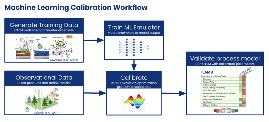
Figure: Schematic of machine learning calibration workflow.
Extending the Emulator Framework Across the Earth System
The emulator-based calibration infrastructure we developed is a flexible, general-purpose scientific tool, and we are actively expanding it to address pressing questions across the Earth system. One spinoff project applies this framework to forest fire risk. By training emulators on ensembles of forest demography model simulations, we are exploring how forest stand structure and plant functional traits influence fire risk and spread under various weather conditions. Preliminary work to generate training data and identify influential traits has led to the development of an interactive tool that enables the community to assess model sensitivities easily. This work bridges land surface modeling, fire ecology, and machine learning in new ways and points toward a new generation of decision-relevant tools for land management. Additional spinoff projects are underway, with a common thread of combining physical and machine-learning models to address previously intractable scientific questions.
For questions or partnership opportunities, please contact David Lawrence.