Real-time AI-Driven Medium-Range Convective Hazard Forecasts
Traditionally, physics-based Numerical Weather Prediction (NWP) systems (e.g., global dynamical models such as GEFS or ECMWF) exhibit strong skill for severe weather over the short-range 1–3 days. Beyond about Day 4, forecast skill for convective hazards, such as tornado-supporting environments, hail, and damaging winds, declines rapidly. Small errors in initial conditions grow quickly in the chaotic atmosphere, and mesoscale processes that drive severe convection are especially difficult to resolve. By Days 6–8, forecasts often show limited reliability and only modest improvement over climatology.
NSF NCAR is using AI NWP emulators to enhance global medium-range weather predictions, extending our ability to predict the locations and intensities of convective weather hazards. Preliminary demonstrations have documented improvements in hazard forecast skill extending up to a week into the future. To further demonstrate the capability of AI for convective hazard prediction, scientists at NSF NCAR have developed a prototype real-time ensemble forecast system based on an AI NWP emulator. Forecasts from this experimental system use two AI NWP emulators to generate 100 ensemble members, each depicting possible outcomes for convective hazard across the U.S. The forecasts also run much faster than traditional NWP, available to scientists and decision-makers in minutes rather than hours. Forecasts are available in real time; a sample forecast is shown below.
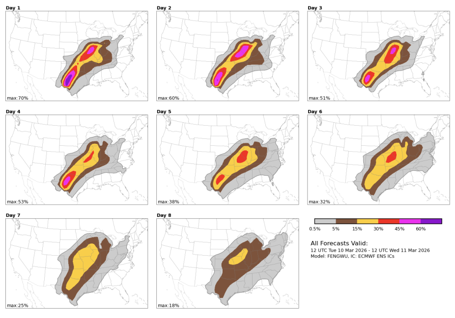
Figure: A sample convective hazards forecast for 10 March 2026. Color shading indicates the probabilities of occurrence of ≥1 convective weather report (tornado, hail, or wind) within 40 km of a point between 12 UTC 10 March 2026 and 12 UTC 11 March 2026.
For more information or partnership opportunities, please contact Ryan Sobash.